
Slave Island (Colombo-2)
Slave Island, the area of Colombo about two kilometres south of the Fort and adjoining Galle Face at its rear was once an island on the Beira Lake. Slave Island consisted of a mud village, a bazaar, an excellent ground, and two “gentlemen’s villas”. Kew Road connected Slave Island to the Fort by bridges and causeways.
The area is pockmarked with many streets and buildings since development work in the city was carried out during and after the British Colonial era. Wekande is one area within Slave Island bordering the Beira Lake on its south.
Today, Slave Island is a very busy commercial area with many government offices, restaurants, hospitals, corporate offices, cinemas, religious places, and residencies. The Headquarters of the Sri Lanka Air Force, Sri Lanka Army, and the City Football League are also located in here.
The first botanical gardens in Colombo were also located here and its links with London’s Kew Gardens are linked to Kew Road.
Still slave to a name
We pass them every day but do we know their significance? In our new series, Dr. K. D. Paranavitana delves into the history of some of Colombo’s famous names and places.
The Colombo Municipality has a ward by the name of ‘Slave Island’, but it is neither an ‘island’ nor are ‘slaves’ found in this area. In the first half of the 20th century, local newspapers carried articles objecting to this name and wasted much ink and energy. Nothing happened and the areacontinued to be called ‘Slave Island’. The Beira Lake: Did Dutch Engineer De Beer build it? Some suggested re-naming it ‘Malay Town’, others preferred the name ‘AfghanTown’ as there were residents of Afghan origin. The best suggestion made by someone in the 1940s was to call the area by the name of the famous lake which graces the location; “why not ‘Beira Town’ or ‘Beira Plain’?”
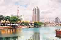

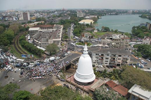
Beira Lake was once the pride and glory of the city of Colombo. For almost three centuries it served as a defence to the fort from the land side. In early British times the lake was used for recreation and amusement. In 1945an anonymous correspondent wrote to the Colombo Observer quoting Martineau’s Cinnamon and Pearls (1853): “The Blue Lake of Colombo. Never loses its charm. The mountain range in the distance is an object for the eye to rest lovingly upon, whether clearly outlined against the glowing sky, or dressed in soft clouds from which Adams Peak alone stands aloft,like a dark island in the waters above the firmament.”
Today, we can hardly expect to see Adam’s Peak over the Colombo Lake on any day of the year, not even from the top of the Twin Towers. Now the Lake is surrounded by concrete constructions and high-rise buildings. At present it is simply a smaller lake than what it was, though the recent changes in thewater’s edge around the Simama Malaka have brought in some picturesque scenes.Nippon Hotel in Slave Island The origin of the word ‘Beira’ and when it was so named are not clear. Some are of the opinion that it was named after a Dutch engineer called ‘De Beer” who had constructed the moats and water defences of Colombo Fort around 1700. Some years ago there was a stone slab at the small sluice of the Beira Lake near the ‘Convention Centre’ bearing the inscription “De Beer: AO 1700”. It is no longer there and nobody knows where it is now.
The Dutch surveyor and town planner Adriaan de Leeuw who designed streets in Pettah in 1659 refrained from giving any particular name to the lake.
Philipus Baldaeus’s map which describes the situation in 1656 referred to it as ‘De Tangh’ (The Tank). During the 17th century, the majority of maps identifies it as ‘D’ Tanck’ (The Tank). A map prepared in 1796 indicates this as ‘D’ Lac, Colombo’ (The Lake, Colombo). The Colombo Lake only came to be referred to as Beira apparently on the maps of Colombo drawn after 1927. The lake covered a large extent of land before its surroundings converted to a settlement in the 16th century.
There were several outlets to carry the spill water of the lake to the sea.One of them was opened to the harbour through a stream flowing across the land on which the present St. John’s Fish Market stands. The other was the Lotus canal and the last was in Mapane or the Galle Face. The lake is about1.8 m. above sea-level and the overflow was made to run along the eastern side of the rampart and reach the harbour through the Lotus canal. This place was called Klein Mutwal or ‘Small Mutwal’ in Dutch times. The largest island of the Beira Lake, the ‘Slave Island’ had been connected to the mainland by filling a section somewhere in the present Union Place.
However, the area retained the original name, throughout the 17th century as it became a place of segregation for the slaves of the Dutch East India Company (VOC) because of the crimes committed by these slaves who were given accommodation in the Fort. One night a slave of a Dutch household in the Fort had murdered an entire family. As a result all the slaves in theFort were lodged in huts just outside the Kasteel or Fort. This slave population, Aegidius Daalman says, was concentrated in a ‘Black Village’ or Niggery.
It was Francois Valentijn who first made a reference to this place using the term ‘Slave Island’. The slaves after carrying water, firewood, and attending to janitorial work in the households in the Fort, were at the end of the day rowed to Slave Island every evening through steps of the Sally Port which lay between Bristol Hotel (it caught fire a few decades ago) and the Registrar General’s Office (the empty land adjoining Hemas building). York Street was the rampart of the Dutch Fort and the road along the lower level while Lotus Road indicates the former banks of the Beira Lake.

An old Dutch painting gives a view of the Beira Lake. The officials of the Dutch East India Company preferred to identify the Slaves’ Quarter as ‘Slave Island’. For the locals, it was Kompanne Veediya. During early British times the ‘Slaves Quarter’ provided a home for the Gun Lascars of the Rifle Regiment. The name Rifle Street retains this legacy, even to date.
Steps were taken by the Governor Stewart Mackenzie (1837-41) to completely abolish slavery and this was finally realised in 1845. But the name Slave Island still adheres to this division of Colombo because there the Dutch provided shelter to their slaves.
The Dutch had a contingent of Ooosterse Militie or ‘Eastern Soldiers’ brought over from Java and they were settled in the Malay Quarter of Slave Island now called Malay Street.
Christopher Schweister in his Account of Ceylon (1676-82) refers to this community and states that ‘they lived in the town altogether with their huts made a very pretty street’. The Slave Island community comprised a colony of Kaffirs as well. They were offspring of slaves from Africa. The Kaffir slaves were mustered at the Kaffirs Veldt (Kaffirs Ground) and had to answer roll-call. James Cordiner in 1807 says that there were 700 Kaffirs in Colombo. This entire community of Kaffirs was extinct beyond recognition within one generation. Captain Thomas
Ajax Anderson in his ‘Wanderings in Ceylon’ (1819) writes;
“Hence, let the eye a circuit take
Were gently sloping to the lake,
A smiling, lively scene appears,
A verdant isle, its bosom rears,
With many lovely villa grac’d
A mid embow’ring cocos plac’d!
Have once, to all but int’rest blind,
The Colonists their slaves confin’d;
But now the name alone remains,
Gone are the scourges, racks and chains!”
(Quoted: Ferguson’s Ceylon in 1903)
The Kompanna Veediya Railway Station
In the 1870s, a railway line was constructed across the Slave Island as the first suburban line leading towards the south, together with a stationabout a mile from the Fort connecting Maradana and Fort.
The station was comparatively small but reflects British colonial style architecture with a small platform and booking office situated at the terminus of Rifle Street. Sinhalese and Tamils called it ‘Kompanne Veediya’ and ‘Kompanne Tervu’ respectively and preserved its historic flavour.
The English retained the old Dutch name and called it ‘Slave Island’. From the railway station this name passed to the post office, to the public offices and ultimately to the entire ward perpetuating the unsavory name.
The Kaffirs
The Portuguese brought around 1,600 ‘Kaffirs’ to Ceylon from Goa, as workmen. They had originally come to Goa from East Africa. The Dutch, later, uswed them as domestic help and labor.
During the 18th century the Kaffir population in Cedylon had grown to large numbers that it gave them a sense of security and strength to stage an insurrection in the city. Besides committing much destruction in the streets and also to private propertry, they also revolted against their employers, some even committing murder.
The Dutch East India Company, at that time, was located in Kollupitiya, very close to the Oberoi Hotel. It is said that one of the Company Officials, Barent Van der Swaan and his wife, were murdered – stabled whilst asleep at night – by one of the slaves working in their bungalow.
The bungalow in which the murders took place was supposed to be haunted and hence unoccupied for many years. When coffee reigned supreme, during the British times, the place was converted into a mercantile store.
The Kaffir insurrection was suppressed and all the slaves were taken along a narrow passage through the ramparts and ferried across the Beira Lake to a jagged peninsular called, IJE, meaning ‘Island’, specially built for them. They had to spend the nights in shanties and tenement houses.
The Dutch used the island to hold the slaves at night, depending on the crocodiles in the lake to prevent them from escaping. The area is now known as Slave Island, the place where the Dutch imprisoned the slaves.
The descendants of the Kaffirs are now concentrated, mainly, in the Batticaloa, Trincomalee, and Puttalam areas. They still sing and perform the Kaffringha, a popular dance form attributed to their community and heritage.
The Malays
During the 17th and 18th centuries, Slave Island was occupied by Javanese and Malay people, who were mostly soldiers who fought and served under the Dutch and British Colonial rulers. The Colombo Malay Cricket Club, formerly located at Riufle Green and now moved to the Jalan Padang at Kew Road, is the oldest cricket club in the whole of Sri Lanka.
Ceylon Cold Stores
The Colombo Ice Company was established in 1866 on the banks of the Beira Lake in Slave Island. Its premises down Glennie Street became known as ‘Ice Kompanniya’, a name that lingers over a century later. Many elders still refer to the Ceylon Cold Stores Ltd., as “Ice Kompanniya”. Over this period the whole district of Slave Island also became to be known as “Kompanni Veediya” meaning Company Street.
Ceylon Cold Stores, later went into the production of aerated waters, ice cream and even many other dairy products and groceries. Today it boasts of a massive supermarket catering to the elite and middle class of Colombo. Milk production and distribution, was also another industry that the Company ventured into and successfully carried out.
It is also reported that, during British times, Slave Island became the home of a Company of the Malay Rifle Regiment. Rifle Street is called Kompanni Veediya for this reason.
Courtesy: The Sunday Times (Colombo) of 18 June 2006